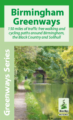
Birmingham Greenways
150 miles of traffic free walking and cycling paths around Birmingham, the Black Country and Solihull
This innovative new map gives a different perspective to Birmingham, the Black Country and Solihull. It features 150 miles of traffic free walking and cycling paths along canals, rivers, and through the 8000 acres of parks of the Birmingham plateau.
Following two years of research it is designed to appeal to a wide range of users who wish to explore the area and its fascinating industrial legacy.
Fully coloured at 1:30,000 it is ideal for tourists and all leisure users, as well as boaters who wish to explore the region away from the canals and is supplemented by information panels and photographs.
Walking: The detailed Birmingham City Plan at 1:15,000 is designed for exploring Birmingham city centre canals on foot and locating tourist attractions, art galleries, museums and shops.
Cycling: Locations of 22 new bike hire centres and 5 Brompton Docks.
Canals: Birmingham Old Main Line (Brindley Canal), Birmingham New Main Line (Telford Canal), Birmingham and Fazeley Canal, Grand Union Canal, Worcester and Birmingham Canal, Tame Valley Canal, Warwick Junction Canal, Digbeth Branch Canal, Stratford-upon-Avon Canal, Dudley No. 2 Canal, Walsall Canal, Rushall Canal, Wednesbury Canal, Wednesbury Old Canal, and Wednesbury Oak Loop.
Rivers and Streams: River Tame, River Rea, River Cole, River Blythe, Bourn Brook, Chad Brook, Merritts Brook, Chinn Brook, Hol Brook, Hawthorne Brook, Plants Brook, Wash Brook, Hockley Brook, Welches Brook, Stonehouse Brook, Griffins Brook, Callow Brook, Spark Brook, Hatchford Brook, Westley Brook.
Water Mills: Over 90 former sites are listed together with explanations of the different uses.
Tourist Information: Over 100 heritage sites and places of interest, railway stations, nature reserves, parks, gardens and open areas, churches, national cycle routes, long distance paths, pubs, shops, and public toilets.
History: Descriptive panels provide the background to 5000 years of Birmingham History, with details of the Romans, the migration of Anglo Saxon tribes, the Norman Conquest, the English Civil War, the Quakers, the Lunar Society, Water Mills, Steam Engines, the Industrial Revolution, and how Birmingham influenced JRR Tolkien, the author of The Hobbit and the Lord of the Rings.
The Mining and Manufacturing District Map of 1836 gives the background to the geography that spurred the building of over 160 miles of canals in the area. There are articles on the canals and the engineers who built them.
Gas Street Basin in Birmingham city centre is featured. This is now bustling with pleasure craft, restaurants and bars. Top entertainment venues such as the NEC, the International Convention Centre, the National Indoor Arena and the Birmingham Rep. are shown as well as the Bull Ring shopping Centre and New Street Station. View the Staffordshire Hoard in Birmingham Museum and Art Gallery.
Other attractions include the Black Country Living Museum, the Dudley and Netherton Tunnels, Farmer’s Bridge Locks, Sandwell Valley Country Park, Bruton Park in Solihull, and Walsall Art Gallery with its world class collection of Jacob Epstein sculptures.
ISBN 978-1908851161 • Price £5.99
The Birmingham Greenways map is available to buy online or by telephone from our business partner, Guidepost. Click on the logo below to visit their store.

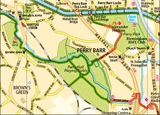
Click on the image above to see an extract from the map - opens in a new window