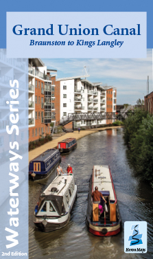
Grand Union Canal
Braunston to Kings Langley
A full colour map of the Grand Union Canal from Braunston to Kings Langley suitable for both waterways and leisure users.
This map gives detailed coverage of the Grand Union Canal from Braunston to Kings Langley with emphasis on the waterways and information useful and relevant to users of the waterways without neglecting other leisure users. The map detail is complimented by information panels and photographs.
The Grand Union Canal is Britain's longest canal, running 137 miles from London to Birmingham. This map covers the central section from Braunston to Kings Langley. The route starts at Braunston heading south westwards across rural Northamptonshire, passing through Weedon Bec, Blisworth and Stoke Bruerne before arriving in Milton Keynes. The canal traverses the city largely hidden behind the greenery of parklands. Exiting the city it continues south westwards through Buckinghamshire, Hertfordshire, and the Chilterns before reaching Hemel Hempstead and the map's most easterly extent of Kings Langley and the M25. The map includes the Northampton, Aylesbury and Wendover Arms and the start of the Leicester Line.
This tourist map of the Grand Union Canal from Braunston to Kings Langley at 1:50,000, with detailed town plans of Braunston, Weedon Bec, Stoke Bruerne, Northampton, Milton Keynes, Fenny Stratford, Aylesbury, Marsworth and Berkhamsted at 1:12,500.
Includes navigation and historical information, visitor moorings, marinas and boatyards, boat hire centres, facilities for the boat user, shops, post offices and distance markers. Information for the tourist includes tourist information centres, places of interest, pubs, nature reserves, parks, churches, long distance paths, public toilets and caravan and camp sites.
Click here to see the area covered by this map
ISBN 978-1908851345 • Price £5.99 • 2nd edition
The Grand Union Canal, Braunston to Kings Langley map is available to buy online or by telephone from our business partner, Guidepost. Click on the logo below to visit their store.

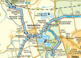
Click on the image above to see an extract from the map - opens in a new window